
Well, this isn't really a paddling trip report, but a land based scouting trip of part of the TYGER River in upstate South Carolina. :roll:
While waiting for some glue to dry on some frames I just assembled for my project; I decided to take a bike ride down into South Carolina to scout some landings on the Tyger noted in both "Paddling South Carolina" and "Carolina Whitewater" guide books.
Mixing my interest in paddling, motorcycle riding and history made for a great "Triple Play" outing.
Where the Tyger starts passing through Sumter NF sounds more like my kind of paddling....as in mostly flat. It has come off the fall line and is mostly settled down by the first crossing I came to.
S-113
The books did not really say much about access here. It did look like you could drag the boats down the South side but I could not tell if the property was posted.
View upstream....

And downstream....looks like the way to go.

So, winding my way downstream by road, I saw this marker.

I rode back down some dirt and gravel roads to see if there was access to the river at this location and learn more about the battle. It is part of the Palmetto Trail, but looked like a longer hike down to the river than I had time for.
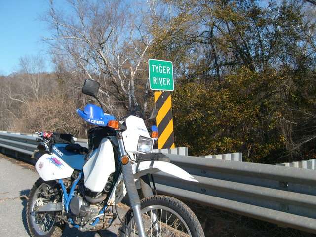
On the the next crossing at SC 49.
Looking upstream...

and downsteam....


There is a "road" down to the water under the bridge, but could be a quagmire when very wet. I was glad my tires had some chunky tread. It was pretty slippery closer to the riverbank
I then rode down to Rose Hill Plantation and the landing at SC 16.


This is a beautiful spot rich in history and natural beauty.
Just down the road on SC16 there is a public landing with good access for small boats.
Looking upstream...

and downstream...

There is a landing at Rose Hill that provides access to the site from the river. A stop to see the place is certainly something to be done when voyaging down the Tyger. With the days being short, I had to start back home before sunset. Scouting the lower reaches will have to be done later.
So, I scooted on home with my traveling buddy and thawed out with some hot chocolate in front of the fireplace.
Random thoughts....
The Tyger was used to transport cotton and other goods downstream from Rose Hill and other plantations to the Broad River and beyond during the 18th and 19th centuries. As you can see from these few pictures, you can imagine there could be plenty of snags and obstructions these days.
The extended drought in the upstate and Western NC has certainly affected the water levels here as well.
Another thought is the first two access points would ,in my opinion,not be good places to leave a vehicle. Logistics and shuttle arrangements would need to be considered.
The guide books list this stretch and beyond as a good piece of water to take an extended trip on.
Hopefully in '09.
:wink: 8) [/img]
While waiting for some glue to dry on some frames I just assembled for my project; I decided to take a bike ride down into South Carolina to scout some landings on the Tyger noted in both "Paddling South Carolina" and "Carolina Whitewater" guide books.
Mixing my interest in paddling, motorcycle riding and history made for a great "Triple Play" outing.
Where the Tyger starts passing through Sumter NF sounds more like my kind of paddling....as in mostly flat. It has come off the fall line and is mostly settled down by the first crossing I came to.
S-113
The books did not really say much about access here. It did look like you could drag the boats down the South side but I could not tell if the property was posted.
View upstream....
And downstream....looks like the way to go.
So, winding my way downstream by road, I saw this marker.
I rode back down some dirt and gravel roads to see if there was access to the river at this location and learn more about the battle. It is part of the Palmetto Trail, but looked like a longer hike down to the river than I had time for.
On the the next crossing at SC 49.
Looking upstream...
and downsteam....
There is a "road" down to the water under the bridge, but could be a quagmire when very wet. I was glad my tires had some chunky tread. It was pretty slippery closer to the riverbank
I then rode down to Rose Hill Plantation and the landing at SC 16.
This is a beautiful spot rich in history and natural beauty.
Just down the road on SC16 there is a public landing with good access for small boats.
Looking upstream...
and downstream...
There is a landing at Rose Hill that provides access to the site from the river. A stop to see the place is certainly something to be done when voyaging down the Tyger. With the days being short, I had to start back home before sunset. Scouting the lower reaches will have to be done later.
So, I scooted on home with my traveling buddy and thawed out with some hot chocolate in front of the fireplace.
Random thoughts....
The Tyger was used to transport cotton and other goods downstream from Rose Hill and other plantations to the Broad River and beyond during the 18th and 19th centuries. As you can see from these few pictures, you can imagine there could be plenty of snags and obstructions these days.
The extended drought in the upstate and Western NC has certainly affected the water levels here as well.
Another thought is the first two access points would ,in my opinion,not be good places to leave a vehicle. Logistics and shuttle arrangements would need to be considered.
The guide books list this stretch and beyond as a good piece of water to take an extended trip on.
Hopefully in '09.
:wink: 8) [/img]
